Interdisciplinary Researcher blending
Remote Sensing, GIS & Robotics
Building technology-driven solutions for environmental sustainability, disaster resilience, and inclusive STEM education in mountainous and data-scarce regions.
Experience Publications
Pokhara, Gandaki Province . Open for Research collaboration, consulting and remote opportunities
About
I am Dinesh Mani Bhandari, a Research Associate at the Center for Environmental and Sustainable Agricultural Research (CESAR) with a strong academic foundation in Mechatronics Engineering (B.Sc.) and Remote Sensing & Geospatial Information Systems (M.Eng.), both from the Asian Institute of Technology, Thailand.
My journey bridges engineering innovation and Earth observation, enabling me to design integrated hardware-software solutions for environmental monitoring and sustainable development. I have a proven record of developing satellite-based monitoring systems for land use, crop dynamics, and surface water, leveraging tools such as Google Earth Engine, UAVs, and multi-source satellite data.
Beyond research, I specialize in automating geospatial workflows, building GIS applications, and transforming complex datasets into actionable insights for environmental and agricultural decision-making. I also create data platforms and STEM-focused educational programs to bring geospatial and robotics innovations into practice for governments, NGOs, and schools.
Professional Experience
Research Associate
Center for Environmental and Sustainable Agricultural Research (CESAR), Pokhara, Nepal
Bridging the gap between high-tech geospatial science and grassroots education and decision-making.
Research Lead & RS-GIS Analyst
Config Nepal Pvt. Ltd., Pokhara, Nepal
Delivered scalable, open-data GIS platforms adopted by local municipalities for improved governance.
Research Fellow
Center for Space Science and Geomatics Studies, IOE, Pokhara, Nepal
Leveraged remote sensing and time-series analysis to monitor crop dynamics and support agricultural decision-making in data-limited Himalayan ecosystems.
Visiting Faculty
Tribhuvan University, IOE, Pokhara, Nepal
Modernizing geospatial pedagogy in Nepali higher education.
RS-GIS Analyst & Developer
Governance Automation Solution Pvt. Ltd., Lalitpur, Nepal
Core PHP, MVC Architecture, GDAL, QGIS, PostGIS
Research Assistant (Earthquake & Tsunami Unit)
Regional Integrated Multi-hazard Early Warning System for Asia and Africa (RIMES), Thailand
Strengthening early warning systems in multi-hazard-prone countries.
Publications
Mishra, B., Bhandari, R., Bhandari, K. P., Bhandari, D. M., et al.
Geomatics Journal · 2023
Bhandari, D. M., Witayangkurn, A., Shibasaki, R., Rahman, M. M.
KICSS IEEE Conference · 2018
Selected Projects
Innovation at the intersection of geospatial science, community resilience, and STEM education.
GeoHazard Reporter
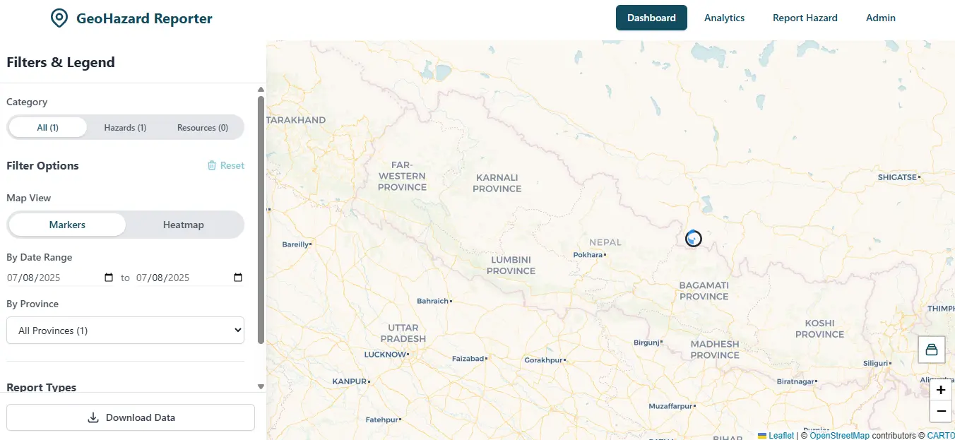
GeoHazard Reporter is a dynamic, community-driven geospatial platform that enables citizens to report, visualize, and monitor geological hazards such as landslides, ground cracks, flooding, and rockfalls. Designed as a Public Participation GIS (PPGIS) tool, it empowers local communities, especially in disaster-prone mountainous regions like Nepal, to contribute critical field observations and strengthen early warning systems.
Live website: https://geohazard.vercel.app/
Mapping Water Hyacinth in Nepal’s Lakes Using Free Satellite Data
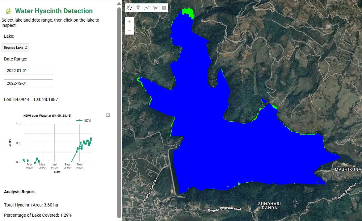
This interactive Earth Engine app enables users to detect and monitor water hyacinth infestations in lakes using satellite imagery. Focused on lakes such as Phewa, Begnas, and Rupa in Nepal, the app combines Sentinel-2 data for vegetation analysis (via NDVI) and Sentinel-1 radar data to map water surfaces.
Live App: Water hyacinth mapper
CESAR STEM Education Program
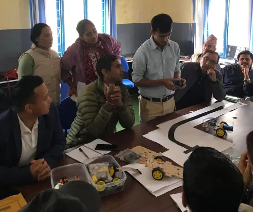
A initiative to bring hands-on science, technology, engineering, and mathematics (STEM) education to rural and semi-urban schools in Nepal. The CESAR STEM program bridges the gap between advanced technology and underserved classrooms, empowering students with 21st-century skills through experiential learning.
As a core contributor, I led the design and implementation of interactive robotics kits, sensor-based experiments, and project-based curricula that integrate real-world environmental monitoring with foundational engineering concepts.
Website: stem.cesar.org.np
Weather Monitoring and Field Station

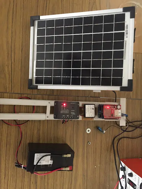
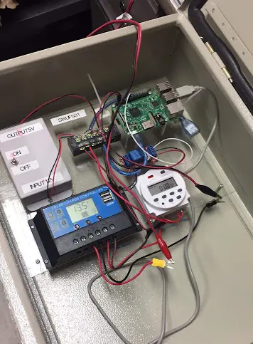
The weather monitoring station is equipped with solar-powered, automated sensors, enabling 24/7 continuous data collection even in remote and off-grid locations. Designed for reliability and sustainability, the system operates independently using renewable energy, ensuring uninterrupted environmental monitoring.
UAV and Multi-Spectral Sensors for Precision Agriculture
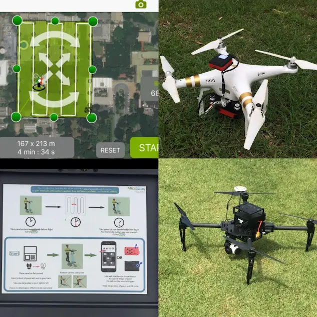
This project explored the integration of Unmanned Aerial Vehicles (UAVs) with lightweight multi-spectral sensors to advance precision agriculture. The goal was to evaluate the performance, practicality, and effectiveness of modern drone-based technologies in monitoring crop health, optimizing resource use, and supporting sustainable farming practices.
Radiation Detector Surveillance Robot
A remote-controlled robot designed to detect radiation in hazardous environments such as nuclear accidents or leaks. Equipped with a tank tread system for rugged terrain mobility, a radiation sensor, and a wireless pan-tilt camera, it transmits real-time video and radiation data to a safe control station. The operator uses a simple remote interface to navigate the robot and assess risks—keeping humans out of danger while enabling fast, informed emergency response.